File:Austria-Hungary map new.svg
Jump to navigation
Jump to search

Size of this PNG preview of this SVG file: 776 × 600 pixels. Other resolutions: 311 × 240 pixels | 621 × 480 pixels | 994 × 768 pixels | 1,280 × 989 pixels | 2,560 × 1,978 pixels | 783 × 605 pixels.
Original file (SVG file, nominally 783 × 605 pixels, file size: 245 KB)

| Description |
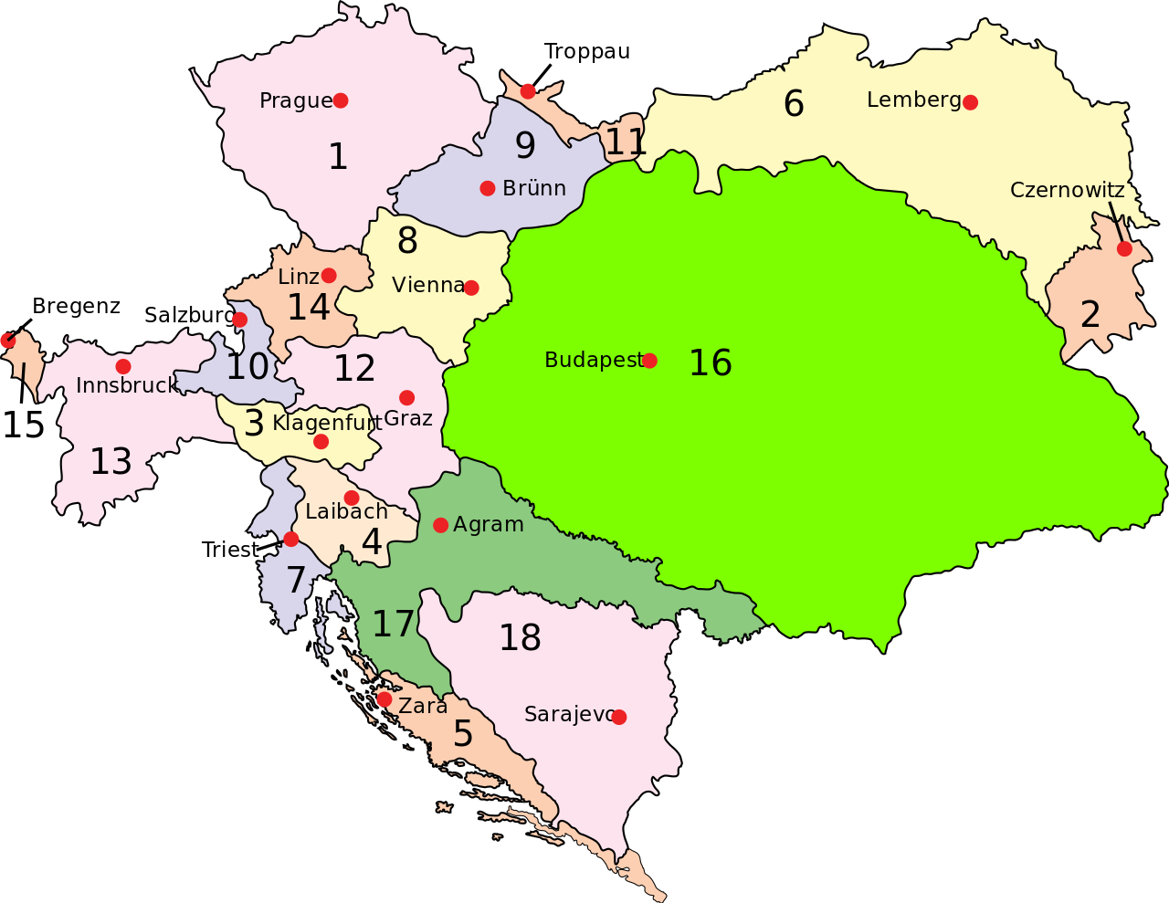
English: Austria–Hungary: Empire of Austria (Cisleithania): 1. Bohemia, 2. Bukovina, 3. Carinthia, 4. Carniola, 5. Dalmatia, 6. Galicia, 7. Küstenland, 8. Lower Austria, 9. Moravia, 10. Salzburg, 11. Silesia, 12. Styria, 13. Tyrol, 14. Upper Austria, 15. Vorarlberg; Kingdom of Hungary (Transleithania): 16. Hungary proper 17. Croatia-Slavonia; Austrian-Hungarian Condominium: 18. Bosnia and Herzegovina Deutsch: Österreich-Ungarn 1910: Cisleithanien: 1. Böhmen, 2. Bukowina, 3. Kärnten, 4. Krain, 5. Dalmatien, 6. Galizien, 7. Küstenland, 8. Österreich unter der Enns, 9. Mähren, 10. Salzburg, 11. Schlesien, 12. Steiermark, 13. Tirol, 14. Österreich ob der Enns, 15. Vorarlberg; Transleithanien: 16. Ungarn, 17. Kroatien und Slawonien; 18. Bosnien und Herzegowina Čeština: Rakousko-Uhersko: Rakouské císařství: 1. České země, 2. Bukovina, 3. Korutany, 4. Kraňsko, 5. Dalmácie, 6. Halič, 7. Rakouské přímoří, 8. Dolní Uhry, 9. Morava, 10. Salcbursko (Solnohradsko), 11. Slezsko, 12. Štýrsko, 13. Tyroly, 14. Horní Uhry, 15. Vorarlbersko; Uherské země: 16. Uhry (Horní a Dolní) 17. Chorvatsko-Slavonie; Rakousko-Uherský kondominát: 18. Bosna a Hercegovina |
||
| Date | (UTC) | ||
| Source | |||
| Author |
|
||
| Permission (Reusing this file) |
|
||
| Other versions | Derivative works of this file: Austria-Hungary map hu.svgImage:Austria-Hungary map-blank.svg, for more maps derived from this template see Category:Maps of Austria-Hungary ssp. or whatlinks |
[[Category:Maps of th
|Permission= |other_versions= }}
| This is a retouched picture, which means that it has been digitally altered from its original version. Modifications: Capital of Dalmatia (5) was Zara today Zadar. The original can be viewed here: Austria-Hungary map.svg:
|
I, the copyright holder of this work, hereby publish it under the following license:
| |
This work has been released into the public domain by its author, Example, at the [[::|English Wikipedia]] project. This applies worldwide. In case this is not legally possible: |
Original upload log
This image is a derivative work of the following images:
- File:Austria-Hungary_map.svg licensed with PD-user-w
Uploaded with derivativeFX
File history
Click on a date/time to view the file as it appeared at that time.
| Date/Time | Thumbnail | Dimensions | User | Comment | |
|---|---|---|---|---|---|
| current | 14:28, 20 February 2009 | | 783 × 605 (245 KB) | wikimediacommons>Ivh123 | {{Information |Description={{en| <br>'''<u>Austria–Hungary</u>''':<br>'''Empire of Austria (Cisleithania)''': 1. Bohemia, 2. Bukovina, 3. Carinthia, 4. Carniola, 5. Dalmatia, 6. Galicia, 7. Küstenland, 8. Lower Austria, 9. Moravia, 10. Salzburg, 11. Si |
File usage
The following page uses this file: