File:Barrage de la Rance.jpg
Jump to navigation
Jump to search

Size of this preview: 800 × 500 pixels. Other resolutions: 320 × 200 pixels | 640 × 400 pixels | 1,024 × 639 pixels | 1,280 × 799 pixels | 1,984 × 1,239 pixels.
Original file (1,984 × 1,239 pixels, file size: 2.57 MB, MIME type: image/jpeg)
Summary
| Description |
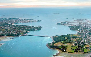
Français : Vue aérienne du barrage et usine marémotrice de La Rance avec en arrière plan Saint-Malo à droite de l'estuaire (Saint-Servan en premier plan, la cité d'Aleth sur la gauche, la ville intra-muros au fond après le port, et derrière celle-ci les îlots du Petit et du Grand Bé) et Dinard à gauche de l'estuaire. On aperçoit également le rocher de Bizieux (le plus proche du Barrage) et l'île de Cézembre (au fond, au centre).
English: Aerial view of the tidal barrage on the Rance and of Saint Malo.
Deutsch: Luftbild des Gezeitenkraftwerks Rance mit den Städten Saint-Malo auf der rechten Seite der Mündung und Dinard links. |
| Date | |
| Source | Own work |
| Author | Tswgb |
| Other versions |

Licensing
| I, the copyright holder of this work, release this work into the public domain. This applies worldwide. In some countries this may not be legally possible; if so: I grant anyone the right to use this work for any purpose, without any conditions, unless such conditions are required by law. |
File history
Click on a date/time to view the file as it appeared at that time.
| Date/Time | Thumbnail | Dimensions | User | Comment | |
|---|---|---|---|---|---|
| current | 11:12, 14 October 2022 | | 1,984 × 1,239 (2.57 MB) | wikimediacommons>Rundvald | Amélioration de la colorimétrie, de la luminosité et des contrastes... |
File usage
There are no pages that use this file.